PACKERY CHANNEL INTRODUCTION
Prepared by Richard L. Watson, Ph.D.
Consulting Geologist
Send
email to Richard Watson
Click on pictures to view them full size.
Return to this page with your
browser back button.
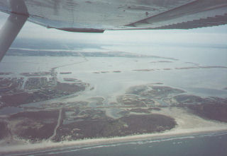
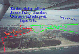
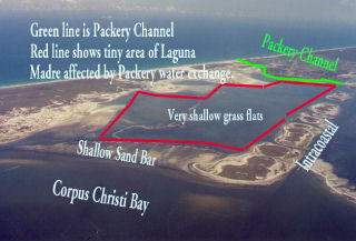
The photos show the location of Packery Channel and the very
small area that
will be affected by tidal exchange due to opening Packery Channel. Most
of that area
is very shallow, on the order of only 2 feet deep. Note that Packery
Channel has
many sharp bends and is quite long. The small, shallow area for tidal
exchange and
the resistance to water flow in the long, winding channel will reduce
the speed of
the water flow, so that the channel will not scour itself of sand.
Virtually all
of the sand deposited in the channels will have to be removed by
dredging at high
cost.
The photo on the left shows a view of the area of tidal exchange
affected
by Packery Channel taken from the south end of Corpus Christi Bay.
There is a shallow
sand bar which will prevent water exchange between Packery Channel and
Corpus Christi
Bay.
The most recent studies by the Corps of Engineers conclude that there
will
be little or no salinity reduction of Laguna Madre or Corpus Christi
Bay by opening
Packery Channel.
We concluded and reported this in 1996. The Packery proponents
are still incorrectly stating that Packery Channel will improve the
salinity in Laguna
Madre. Packery Channel will have a smaller effect on Laguna Madre than
a soda straw
would have on an olympic swimming pool.
The original pass did not go from
the proposed entrance of Packery Channel to the vicinity of the
Intracoastal Canal
in Laguna Madre as shown by the green line. The original pass was a
pass to Corpus
Christi Bay, not a pass to Laguna Madre. It went from about the "Sh" in
"Shallow Sand Bar"and came out above the "nn" in "Packery
Channel", a nearly straight line from its entrance to Corpus Christi
Bay.
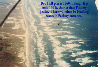
The
photo on the right shows Bob Hall Pier, located about 2 miles south of
Packery Channel.
On many days a year we have waves breaking well beyond the end of Bob
Hall Pier as
shown. The jetties as planned for Packery Channel are just 140 feet
longer than Bob
Hall Pier. This means that on many days there will be dangerous
breaking waves in
and beyond the entrance to the jetties at Packery.
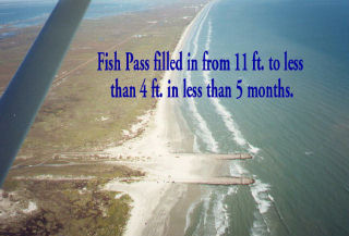
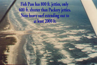
The Fish Pass which is just a few miles to the north of Packery
Channel was
built in 1972 to enhance fish migrations and to serve as a small boat
pass. Legislation
prevented its use for boats. The fish pass jetties were originally 800
feet long.
It was dredged to a depth of 11 feet and filled in at the jetties to
less than 4
feet in less than 5 months. In less than a year, the Corpus Christi Bay
side of the
pass filled in to only 1 foot deep. Look at how the Fish Pass looks
under heavy surf
conditions. The waves are not only breaking at the far, far beyond the
end of the
800 ft. jetties, they are breaking far beyond the 1400 ft. length of
the jetties
planned for Packery Channel.