TEN YEARS AGO PACKERY CHANNEL WAS A BAD IDEA.
IT IS STILL A BAD
IDEA.
Richard L. Watson, Ph.D.
March, 1996 Forum article Corpus Christi Caller
Times
TEN YEARS AGO PACKERY CHANNEL WAS A BAD IDEA.
IT IS STILL A BAD
IDEA.
There is nothing new about Packery Channel. There have been several
forum presentations and numerous letters to the editor supporting the
opening of
Packery Channel. Many of these state that this is a new proposal and
previous objections
to the project are not applicable. It has even been stated by Naismith
engineering
that comparison should not be made with the very unsuccessful Fish
Pass. These statements
are far from the truth. The only change is that the developers now want
the taxpayer
to build and maintain the project. The natural systems affecting the
success of Packery
Channel have not changed.
Major coastal engineering structures which intercept
the flow of sand along the beaches should not be made unless they are
absolutely
necessary. In the vicinity of Packery Channel, the sediment transport
in the surf
zone carries about 726,000 cubic yards of sand along the beach each
year. This amounts
to one 8 cubic yard dump truck each 6 minutes all year long. That is
about 250 dump
trucks per day. Coastal engineering structures such as passes and
jetties interrupt
this system. Modifying a 250 dump truck per day natural transport
system risks major
beach erosion problems in the future.
Coastal engineering structures along
the barrier islands of New Jersey have so altered the natural system
that they now
have rock jetties nearly every city block in some areas and still have
to artificially
nourish the beaches by pumping sand onto them regularly. New Jersey got
into that
predicament by building a few structures such as jetties and seawalls
which affected
the sediment flow along the coast. This of course interrupted the flow
of sand and
starved other beaches resulting in a need for yet more coastal
engineering structures.
It never stops. {See Photos of N.J. Coast Below}
Erosion of the beaches in
front of the Padre island seawall is being used as partial
justification for opening
Packery Channel. The sand dredged from Packery Channel can be used to
nourish the
beach in front of the seawall. The beach erosion was caused by the
seawall and now
a second engineering structure is suggested as the remedy. That problem
can be solved
without building new jetties by dredging sand from the back side of
Padre Island
onto the beach. Interrupting the natural transport system which carries
the sand
which maintains our beaches is always a risky proposition which
generally leads to
more beach erosion at other locations and a succession of ugly,
expensive and not
very successful coastal engineering structures.
The history of the shoaling
of the Fish Pass and the water flow through it should serve as the
model against
which to judge the probable success or failure of Packery Channel. The
Fish Pass
was constructed in a far better location for success than Packery
Channel. Packery
channel will connect with the very shallow nearly completely filled
north end of
Laguna Madre. There is effectively no basin to support tidal flow. The
Fish Pass
shoaled to about 4 feet from 11 feet at the Gulf mouth in just three
months and shoaled
to only 2 feet at the bay mouth in less than one year. Most of the
time, the Gulf
mouth was impassable to even a 16 ft. Boston whaler with a skilled
operator because
the jetty channel contained breaking surf. By June of 1975, the channel
near the
jetties was reduced to a cross section of only 277 square feet. A short
time later
the Fish Pass closed completely.
Packery Channel will not restore the upper
Laguna Madre and Corpus Christi Bay to the natural condition which
existed before
construction of the Kennedy Causeway, and the Corpus Christi Ship
Channel. The ship
channel is bigger than can be maintained by the natural tidal and river
flow and
does not leave enough natural circulation to help maintain an
artificial pass. The
maintenance expense of Packery Channel will be enormous. All tidal
inlets on barrier
island coasts transport a huge amount of beach sand through them and
deposit it in
the bay. This is how the north end of Laguna Madre between the Kennedy
Causeway and
Corpus Christi bay became nearly completely filled before the turn of
the century
when Packery Channel was open. It is how Harbor Island at and the
surrounding flats
came to exist inland of the historic location of the natural Aransas
Pass inlet.
Packery Channel is no exception and huge amounts of our beach sand will
flow in and
further shoal and restrict circulation in Laguna Madre.
The amount of tidal
exchange through Packery Channel will be insignificant with regard to
the volume
of water in Laguna Madre and will affect the water quality of Laguna
Madre at most
for only a few miles. The maximum amount of water entering the Fish
Pass in a flood
tidal cycle during its first year of operation was only 118 million
cubic feet. That
sounds like a lot of water, but it is only 4.2 feet deep spread out
over one square
mile. Spread out over all of northern Laguna Madre it is less than six
hundredths
of an inch. In addition, water masses of different salinities such as
the bay water
and the Gulf water do not mix well. Packery Channel will have even
smaller flow than
the Fish Pass. The effect on salinity, and brown tide will probably not
be felt beyond
one or two miles from the pass.. It is comparable to affecting the
water quality
of an Olympic swimming pool with a soda straw.
Packery Channel will be a
hazard to navigation. Packery Channel has been touted as being a safer
boat pass
than the Ship Channel. The commercial traffic in the ship channel is no
hazard at
all compared with the hazard of running a narrow, shallow inlet on an
outgoing tide
with an onshore wind. This will be the condition on many afternoons
when small boats
are returning home from a day on the Gulf. Many of the boat operators
will have neither
the skill nor a suitable boat for running a surfing inlet right next to
the rocks.
It took the Fish Pass only a few months to shoal from a safely
navigable small boat
inlet to one nearly impossible to get through even with a skilled boat
operator.
In
thirty years of experience studying the beaches, passes, surf, currents
and bays
of the Texas Coast and a lifetime of operating boats along all of the
Gulf and Atlantic
coasts from Brownsville to New York, I have never seen an inlet built
or proposed
to be built in a worse location than Packery Channel.
Richard L. Watson,
Ph.D.
Marine Geologist
Click on pictures to view them full size
Use the back button
on your browser to return here.
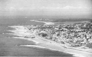
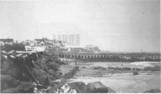
Erosion control stuctures in N.J.
Cape May, N.J. on the left, Asbury Park,
N.J. on the right
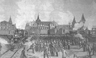
Locomotives moving hotel due to beach erosion,
Coney Island, New York